Sunday, August 25, 2013

Instruction of how to install gps map on gps device| GPS Map, iGO, Garmin, Route66, garmin updates, igo 2014 gps map, igo australia, gps updates, gps map software

Areas OF Free shipping GPS MAP SD CARD or TF Micro SD card Memory card with lastest IGO9/8 GPS maps


The district of GPS Map:
we have almost whole world GPS Map!!!
if you have not find your country GPS map,pls contact us.

EURO :
Russian
Albania, Andorra, Austria, Belarus, Belgium, Bosnia, Bulgaria, Croatia, Cyprus, Finland, France, FYROM, Germany, Gibraltar, Greece, Hungary, Ireland, Italy, Latvia, Liechtenstein,Lithuania, Luxembourg, Malta, Moldova, Monaco, Montenegro, Netherlands, Norway,Poland, Portugal, Romania, Russia, SanMarino, Serbia, Slovakia, Slovenia, Spain, Sweden, Switzerland, Turkey, Ukraine, UnitedKingdom, Vatican, CzechRep, Denmark,Estonia.

Aisa/Africa:
Middle East
Bahrain, Brunei, Egypt, HongKong, Indonesia, Israel, Kuwait, Macao, Malaysia, Oman, Qatar, SaudiArabia, Singapore, SouthAfrica, Taiwan, Thailand, UnitedArabEmirates.
North America
USA Canada Mexico

USA detail:Alabama, Alaska, Arizona, Arkansas, Californial, Colorado, Connecticut, Delaware, Columbia, Florida, Georgia, Hawaii, Idaho, Illinois, Iowa, Kansas, Kentucky, Louisiana, Maine, Maryland, Massachusetts, Michigan, Minnesota, Mississippi, Missouri, Montana, Nebraska, Nevada, New Hampshire,New Jersey,New Mexico, New York,North Dakota, Ohio, Oklahoma, Oregon, Pennsylvania, Puerto Rico, Rhode Island.South Carolina, South Dekota, Tennessee, Texas, Utah, Vermont, Virgin Islands, Virginia, Washington, West Virgina, Wisconsin, Wyoming


South America:

Argentina, Brazil.Chile, Brazil and Argentina,Venezuela, Colombia

Oceania
Australia New Zealand


The resolution of GPS equipment is usually 800x480 or 480x272 or 480x234, please finds out the file sys.txt and edits the right resolution for your Car GPS devices
normailly resolution was 800*480

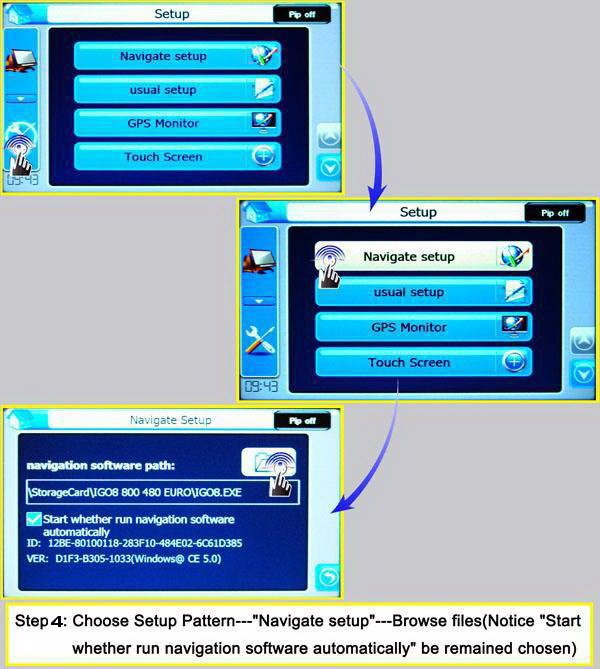
Visual Instructions on how to install SD Card
The resolution of GPS equipment is usually 800x480 or 480x272,Wince 5.0 or WinCE6.0, please finds out the file sys.txt and edits the right resolution for your Car GPS devices.It's very easy to use.
note: this map default "port=1" and "baud=4800" can work on all car GPS/DVD which can support IGO8 map,if you device use port 2, please change the "port=1" to "port=2" under the file "sys.txt" and change the right baud,thanks
Features:

The district of GPS Map:

Whole EURO :

Albania, Andorra, Austria, Belarus, Belgium, Bosnia, Bulgaria, Croatia, Cyprus, Finland, France, FYROM, Germany, Gibraltar, Greece, Hungary, Ireland, Italy, Latvia, Liechtenstein,Lithuania, Luxembourg, Malta, Moldova, Monaco, Montenegro, Netherlands, Norway,Poland, Portugal, Romania, Russia, SanMarino, Serbia, Slovakia, Slovenia, Spain, Sweden, Switzerland, Turkey, Ukraine, UnitedKingdom, Vatican, CzechRep, Denmark,Estonia.

Aisa/Africa:

Bahrain, Brunei, Egypt, HongKong, Indonesia, Israel, Kuwait, Macao, Malaysia, Oman, Qatar, SaudiArabia, Singapore, SouthAfrica, Taiwan, Thailand, UnitedArabEmirates.

USA:

Alabama, Alaska, Arizona, Arkansas, Californial, Colorado, Connecticut, Delaware, Columbia, Florida, Georgia, Hawaii, Idaho, Illinois, Iowa, Kansas, Kentucky, Louisiana, Maine, Maryland, Massachusetts, Michigan, Minnesota, Mississippi, Missouri, Montana, Nebraska, Nevada, New Hampshire,New Jersey,New Mexico, New York,North Dakota, Ohio, Oklahoma, Oregon, Pennsylvania, Puerto Rico, Rhode Island.South Carolina, South Dekota, Tennessee, Texas, Utah, Vermont, Virgin Islands, Virginia, Washington, West Virgina, Wisconsin, Wyoming

Canada/South America:

Canada Mexico, Argentina, Brazil.

Australia

The resolution of GPS equipment is usually 800x480 or 480x272 or 480x234, please finds out the file sys.txt and edits the right resolution for your Car GPS devices

Wednesday, August 7, 2013

Full map of europe in 2013, Europe map 2013, igo gps map 2013, Full Europe 2013 GPS Map of iGO 2D 3D GPS map software

Product Information:

Manufacturer: iGO  Category: Europe Navi Map Card Type: Micro SD/SD
Model: 120-1230-50 SKU: EUFUIG13 Sub-Category: Full Europe
Announced: Feb  2013 First Shipped: Feb. 15 2013 Weight: 10g


About Coverage:

With this purchase, you'll have access to the entire coverage map, including:
       Full Europe --  
           Albania
           Andorra
           Austria
           Belarus
           Belgium
           Bosnia Herzegovina
           Bulgaria
           Croatia
           Czech Republic
           Denmark
           Eastern Europe
           Estonia
           Finland
           Former Yugoslav Republic of Macedonia
           France
           Germany
           Gibraltar
           Greece
           Hungary
           Iceland
           Ireland
           Italy
           Kosovo
           Latvia
           Liechtenstein
           Lithuania
           Luxembourg
           Malta
           Moldova
           Monaco
           Montenegro
           Netherlands
           Norway
           Poland
           Portugal
           Romania
           Russia
           San Marino
           Serbia
           Slovakia
           Slovenia
           Spain
           Sweden
           Switzerland
           Turkey
           Ukraine
           United Kingdom
           Vatican City
           Western Europe


Features & Tips:

Here is a listing we have put together of some of the common Full Europe  Full Europe 2013 GPS Map of  iGO 2D 3D  GPS map software with Micro SD/SD Card  along with a few user tips that you may find of help for this particular item.
    • Version: IGO 9.2.1.178658
    • Data update: Feb  2013
    • Run on Windows CE, support iPhone and Android system too.
    • Support from high definition: 800*480 to low definition 240*240
    • It can not be upgraded
    • The map is stored in a 4G TF card by default.


What's Included In The Box?

The Full Europe 2013 GPS Map of  iGO 2D 3D  GPS map software with Micro SD/SD Card Free Shipping ships with the following items included:
  •      TF(Micro SD) card/SD card with Full Europe 2013 GPS Map of  iGO 2D 3D  GPS map software with Micro SD/SD Card .


Map Interfaces On GPS Devices:

  • WinCE System Interface:

    Android System interfaces:
    iPhone/iPad Interface:


Tuesday, August 6, 2013

GPS Map Update Of 'How GPS Works', Latest gps map Free


What is GPS?

world1
The Global Positioning System (GPS) is a satellite navigation system that sends and receives radio signals. It was originally placed into orbit by the U.S. Department of Defense which continues to maintain the system.
GPS is made up of a network of at least 24 satellites that circle the earth twice a day from about 19,000 kilometres above us. Each satellite moves at 11,000 kilometres per hour while continuously transmitting time-based signals to earth that indicate its location.

How do GPS devices, such as navigation systems, use GPS information?

world2
A navigation device uses time based signals from multiple GPS satellites to determine longitude, latitude and altitude, providing your position on Earth. Using these signals in conjunction with accurate digital maps, such as GPSMAPSTORE, your device can pinpoint where you are, and determine the best route to get you to your destination. As these signals are being constantly sent, your device can recognise when you have deviated from the proposed route and can calculate the best path to get you on track.

How does GPS improve navigation?

world3
GPS provides basic information of longitude, latitude and altitude, but once you marry that information up to accurate digital maps, such as GPSMAPSTORE, you open up a world of navigation possibilities. Once a GPS device knows where you are, it can pinpoint that on a digital map as well as provide walking or driving directions to any other position on that map.